How Satellite Imagery Is Changing Archaeological Discoveries
Satellite imagery has become a game-changer in the field of archaeology, revolutionizing the way researchers uncover ancient mysteries and understand past civilizations. By harnessing the power of satellites orbiting high above the Earth, archaeologists are now able to delve into the depths of history like never before.
Imagine being able to identify hidden archaeological sites without even setting foot on the ground. With satellite imagery, this has become a reality. By analyzing high-resolution images captured from space, researchers can pinpoint buried structures, lost cities, and other remnants of the past that are invisible to the naked eye.
Not only does satellite technology unveil hidden sites, but it also allows archaeologists to monitor changes in landscapes over time. By comparing images taken at different points, experts can track the impact of urban development, natural disasters, and environmental shifts on ancient settlements, providing valuable insights into how civilizations evolved.
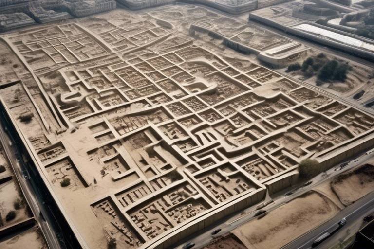
Furthermore, satellite imagery aids in the meticulous mapping of ancient civilizations. Through detailed aerial surveys, researchers can create comprehensive maps showcasing the infrastructure, agricultural practices, and trade routes of past societies. This bird's-eye view offers a unique perspective on how our ancestors lived, worked, and interacted with their environment.
One of the most critical roles of satellite imagery is the preservation of cultural heritage. By keeping a watchful eye from above, archaeologists can safeguard historical sites from threats like looting, vandalism, and unchecked development. This proactive approach ensures that our cultural treasures remain intact for future generations to appreciate.
Moreover, satellite technology opens doors to exploration in remote and inaccessible areas. Whether it's the depths of dense jungles or conflict-ridden zones, satellites provide a safe and efficient means for archaeologists to study sites that would otherwise be off-limits. This capability broadens the scope of archaeological research and uncovers hidden stories from the past.
Utilizing advanced software and analytical techniques, archaeologists can delve deep into the data collected from satellites, extracting valuable information and interpreting it within the historical context. This data analysis enhances our understanding of past human activities, shedding light on ancient mysteries and cultural practices.
Furthermore, satellite imagery fosters global collaboration among archaeologists. By sharing data, expertise, and resources across borders, researchers can undertake large-scale projects and tackle archaeological challenges on a global scale. This interconnected approach propels the field forward and leads to groundbreaking discoveries.
Looking ahead, the future of archaeological research holds endless possibilities with satellite imagery. From artificial intelligence to 3D modeling and multispectral imaging, technological advancements promise to unveil new insights into the past. As we continue to push the boundaries of exploration, satellite technology stands at the forefront of archaeological innovation.

Identification of Hidden Sites
When it comes to uncovering hidden archaeological sites, satellite imagery is a game-changer. Imagine being able to peer beneath the earth's surface without even lifting a shovel. With the power of satellite technology, archaeologists can now identify buried or obscured sites that remain invisible to the naked eye. This revolutionary approach eliminates the need for extensive fieldwork, saving time and resources while opening up a world of new discoveries.
By analyzing high-resolution satellite images, researchers can pinpoint potential archaeological sites based on subtle variations in vegetation, soil composition, or topographical features. These hidden gems, once concealed from view, are now brought to light, offering a treasure trove of insights into ancient civilizations and their way of life.
Moreover, satellite imagery allows archaeologists to survey vast landscapes from a bird's eye view, enabling them to identify patterns and anomalies that may indicate the presence of buried structures or artifacts. This aerial perspective offers a unique vantage point, revealing hidden sites that have long eluded detection.
Through the lens of satellite technology, the past is no longer confined to the depths of history but emerges vividly on digital screens, waiting to be explored and unraveled. The ability to identify hidden sites with precision and efficiency marks a paradigm shift in archaeological research, ushering in a new era of discovery and exploration.

Monitoring Landscape Changes
Satellite imagery is revolutionizing archaeological research by uncovering hidden ancient sites, tracking changes in landscapes over time, and providing valuable data for mapping historical civilizations. This technology is reshaping the way archaeologists explore and understand the past.
Satellite imagery enables the identification of buried or obscured archaeological sites that are not visible on the ground, helping researchers discover new locations without the need for extensive fieldwork.
Monitoring landscape changes through satellite imagery is like having a time machine that captures the evolution of the Earth's surface. By comparing satellite images taken at different times, archaeologists can track changes in landscapes caused by urbanization, natural disasters, or climate change. This provides valuable insights into the development and transformation of human settlements over time.
Satellite technology allows for the creation of detailed maps of ancient civilizations, offering a bird's eye view of their infrastructure, agricultural practices, and trade networks. These maps provide archaeologists with a comprehensive understanding of how past societies lived, interacted, and shaped their environments.
The preservation of cultural heritage sites is a paramount concern for archaeologists. Satellite imagery plays a crucial role in monitoring and protecting these sites from various threats, ensuring that the remnants of our history are safeguarded for future generations to explore and appreciate.
Satellite imagery opens up new frontiers for archaeological exploration in remote and inaccessible regions. It allows researchers to study sites in challenging environments or conflict zones where traditional fieldwork may be impractical or risky. This technology transcends physical barriers, enabling archaeologists to uncover secrets hidden in the most remote corners of the world.
Advanced software and techniques are employed by archaeologists to analyze satellite data, extracting valuable information that sheds light on past human activities. By interpreting these findings in the context of historical research, researchers deepen their understanding of ancient civilizations and the cultural landscapes they inhabited.
Satellite imagery fosters international collaboration among archaeologists, breaking down geographical boundaries and facilitating the exchange of data, expertise, and resources. This global cooperation enables the undertaking of large-scale research projects and the collective effort to tackle archaeological challenges on a worldwide scale.
The future of archaeological research is intertwined with the advancements in satellite imagery technology. Artificial intelligence, 3D modeling, and multispectral imaging are poised to revolutionize the field, offering new tools and methodologies to uncover deeper insights into the mysteries of the past.

Mapping Ancient Civilizations
Satellite technology has opened up new horizons for archaeologists in mapping ancient civilizations. Through the lens of satellite imagery, researchers can now create intricate maps that offer a detailed glimpse into the past. These maps go beyond mere geographical layouts; they delve into the heart of ancient societies, revealing their infrastructure, agricultural practices, and intricate trade networks. It's like peering through a time machine, witnessing how past civilizations thrived and interacted with their environment.
Imagine being able to trace the footsteps of ancient traders as they navigated through bustling marketplaces or following the irrigation systems that sustained agricultural communities centuries ago. Satellite imagery provides a bird's eye view of these historical landscapes, allowing archaeologists to piece together the puzzle of ancient civilizations with unprecedented clarity.
Moreover, these detailed maps serve as invaluable resources for researchers seeking to understand the broader context of historical societies. By mapping out ancient civilizations, archaeologists can gain insights into the social structures, economic activities, and cultural practices that shaped these communities. It's not just about plotting points on a map; it's about unraveling the intricate tapestry of human history woven across time and space.
Furthermore, satellite imagery aids in the preservation of cultural heritage by documenting and monitoring archaeological sites. These maps act as digital archives, safeguarding the legacy of past civilizations against threats like looting, vandalism, or natural disasters. By mapping ancient civilizations, researchers are not just uncovering history; they are also safeguarding it for future generations to cherish and learn from.
Through the lens of satellite technology, the past comes alive in vivid detail, allowing us to explore the remnants of ancient civilizations from a whole new perspective. The ability to map out these historical landscapes with precision and clarity is a testament to the transformative power of satellite imagery in reshaping our understanding of the past.

Preservation of Cultural Heritage
Satellite imagery plays a crucial role in the preservation of cultural heritage sites around the world. By providing detailed and up-to-date images of these sites, satellite technology helps in monitoring and protecting them from various threats that could lead to their destruction or deterioration.
One of the key benefits of using satellite imagery for cultural heritage preservation is the ability to detect and prevent looting and vandalism. By closely monitoring these sites from above, authorities can identify any unauthorized activities and take necessary actions to safeguard the historical significance of the locations.
In addition to preventing physical damage, satellite imagery also aids in managing the development around cultural heritage sites. By tracking changes in the surrounding landscapes, archaeologists and conservationists can advocate for measures to limit urban expansion or construction projects that could encroach upon these valuable areas.
Moreover, satellite technology assists in assessing the impact of natural disasters on cultural heritage sites. By capturing images before and after such events, researchers can evaluate the extent of the damage and plan restoration efforts to preserve the historical integrity of the affected locations.
Furthermore, satellite imagery is instrumental in documenting and creating detailed records of cultural heritage sites. These high-resolution images serve as valuable resources for researchers, allowing them to study the sites in intricate detail and develop comprehensive conservation strategies for long-term preservation.
Overall, the use of satellite imagery in the preservation of cultural heritage not only helps in safeguarding these irreplaceable treasures but also contributes to raising awareness about the importance of protecting our shared human history for future generations to appreciate and learn from.

Exploration in Remote Areas
Exploration in remote areas presents a unique set of challenges for archaeologists, often requiring innovative approaches to uncovering hidden historical treasures. Satellite imagery has become a valuable tool in overcoming these obstacles, allowing researchers to delve into remote and inaccessible regions with unprecedented ease and efficiency. By utilizing high-resolution images captured from space, archaeologists can study sites in environments that would otherwise be difficult or dangerous to access.
One of the key advantages of satellite imagery in remote exploration is its ability to provide a comprehensive view of large geographical areas, enabling researchers to identify potential archaeological sites without the need for extensive ground surveys. This technology offers a bird's-eye perspective that can reveal patterns, structures, and anomalies that may go unnoticed from the ground, leading to the discovery of previously unknown ancient settlements or artifacts.
Moreover, satellite imagery is particularly beneficial for exploring remote areas that are plagued by conflict or political instability, where on-site fieldwork may be risky or impractical. By remotely studying these regions from above, archaeologists can gather valuable data without putting themselves in harm's way, ensuring the safety of both researchers and the cultural heritage they aim to preserve.
In addition to aiding in the initial identification of archaeological sites, satellite imagery also plays a crucial role in ongoing research and monitoring efforts in remote areas. By capturing images over time, researchers can track changes to sites caused by natural processes or human activities, helping to understand the impact of environmental factors on ancient civilizations and heritage sites.
Furthermore, the use of satellite technology in remote exploration fosters collaboration among archaeologists from around the world, allowing experts to share data and insights across borders. This global cooperation not only enhances the scope and scale of archaeological research projects but also promotes the exchange of knowledge and expertise, leading to a more comprehensive understanding of the past.

Data Analysis and Interpretation
When it comes to archaeological research, data analysis and interpretation play a crucial role in extracting valuable insights from satellite imagery. By utilizing advanced software and techniques, archaeologists can delve deep into the data captured by satellites to uncover hidden patterns, trends, and anomalies that may not be visible at first glance.
One of the key aspects of data analysis is the ability to process vast amounts of information efficiently. Satellite imagery provides researchers with a wealth of data, ranging from high-resolution images of archaeological sites to multispectral data that reveals different aspects of the landscape. Through careful analysis, archaeologists can identify potential excavation sites, trace ancient trade routes, and reconstruct past environments.
Moreover, data interpretation involves placing the findings within the broader context of historical research. By combining satellite data with ground surveys, historical records, and other sources of information, archaeologists can piece together a more comprehensive understanding of past human activities. This interdisciplinary approach allows researchers to validate hypotheses, refine interpretations, and contribute to the collective knowledge of ancient civilizations.
In addition to traditional methods of analysis, modern technologies such as artificial intelligence and 3D modeling are increasingly being integrated into archaeological research. These tools enable researchers to automate data processing, visualize complex datasets, and simulate ancient landscapes with unprecedented accuracy. By harnessing the power of technology, archaeologists can explore new research avenues and gain fresh perspectives on archaeological discoveries.
Overall, data analysis and interpretation are essential components of utilizing satellite imagery in archaeological research. By combining cutting-edge technology with traditional archaeological methods, researchers can unlock the secrets of the past and advance our understanding of ancient civilizations.

Collaboration and Global Research
Collaboration and Global Research in archaeology have been significantly enhanced by the utilization of satellite imagery. This technology has broken down geographical barriers, allowing experts from around the world to work together seamlessly. By sharing data, expertise, and resources, archaeologists can now conduct large-scale research projects that were previously unimaginable. The ability to collaborate globally has not only accelerated the pace of archaeological discoveries but has also fostered a sense of unity and cooperation among researchers.

Future Applications and Innovations
Satellite imagery has paved the way for exciting future applications and innovations in the field of archaeological research. With technology continuously evolving, the possibilities for uncovering new insights into the past are endless. One of the potential advancements lies in the integration of artificial intelligence (AI) with satellite data analysis. AI algorithms can help process vast amounts of imagery quickly and efficiently, assisting archaeologists in identifying patterns, anomalies, and potential archaeological sites that may have gone unnoticed before.
Furthermore, the utilization of 3D modeling based on satellite imagery can offer immersive experiences for researchers and the public alike. By reconstructing ancient landscapes and structures in three dimensions, archaeologists can gain a deeper understanding of how these civilizations functioned and interacted with their environment. This visual representation can also aid in educational outreach and public engagement, bringing history to life in a captivating way.
Another exciting prospect is the use of multispectral imaging in archaeological studies. By capturing images beyond the visible spectrum, such as infrared or ultraviolet wavelengths, researchers can detect subtle variations in vegetation, soil composition, or buried features that may not be apparent in standard satellite photos. This advanced imaging technique can provide valuable data for identifying archaeological sites, mapping ancient landscapes, and monitoring changes in cultural heritage sites over time.
Frequently Asked Questions
- How does satellite imagery contribute to archaeological discoveries?
Satellite imagery aids archaeologists in identifying hidden sites, monitoring landscape changes, mapping ancient civilizations, preserving cultural heritage, exploring remote areas, and analyzing data for a deeper understanding of historical activities.
- What are the benefits of using satellite technology in archaeology?
The benefits include the ability to uncover new archaeological sites without extensive fieldwork, track environmental changes over time, create detailed maps of past civilizations, protect cultural heritage sites, and conduct research in challenging or inaccessible regions.
- How does satellite imagery support global collaboration in archaeological research?
Satellite technology fosters international collaboration by enabling archaeologists to share data, expertise, and resources across borders, facilitating large-scale research projects and addressing global archaeological challenges collectively.
- What future innovations can be expected in archaeological research with satellite imagery?
Future innovations may include the integration of artificial intelligence, 3D modeling, and multispectral imaging to uncover new insights into the past, further enhancing the capabilities of satellite imagery in archaeological exploration and interpretation.